Update : 2021-12-2
Where is Soka
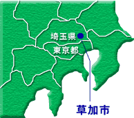
Soka City is in the southeast corner of Saitama Prefecture and shares it’s southern border with Adachi-ku (city) of Metropolitan Tokyo. Situated in the middle of the Nakagawa-ayase Basin, Soka enjoys an abundance of water and greenery. Stretching 7.24km east to west and 7.6km north to south, Soka has a total land area of 27.42 square kilometers.
City Crest
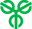
The crest is a combination of the first Chinese character of Soka (草)in its ancient form (艸)and the character for strength(力). The 3 circles represent the 2 towns and 1 village incorporated to form Soka and the 3 lines represent the incorporation of the 3 areas.
City Flower: Chrysanthemum
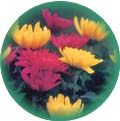
Commemorating Soka’s 15th birthday, the chrysanthemum was adopted based on citizen submissions. Summer and autumn chrysanthemums are a colorful part of the Yatsuka and Shinden areas of Soka.
City Tree: Pine
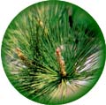
Commemorating Soka’s 15th birthday, the Black Pine Tree was adopted based on citizen submissions. The row of pine trees referred to as “Soka Matsubara” is a symbol of the history and culture of Soka.
Symbol Mark

Designed to celebrate Soka’s 35th birthday, the symbol mark is based on the harp and also represents the flow of the Ayase River and the trunks of the Pine trees.